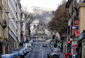
Rue Louis-Ricard الإنجليزية (Q2642357)
street in Rouen, France الإنجليزية
| اللغة | التسمية | الوصف | أسماء أخرى |
|---|---|---|---|
| العربية | لم تُضف التسمية |
لا يوجد وصف |
|
| الإنجليزية | Rue Louis-Ricard |
street in Rouen, France |
بيانات
Wikidata item الإنجليزية
instance of الإنجليزية
country الإنجليزية
image الإنجليزية
Руан ул. Луи Рукар 2014 - panoramio.jpg
١٬٢٠٠ × ٨١٣؛ ٧٠٢ كيلوبايت
١٬٢٠٠ × ٨١٣؛ ٧٠٢ كيلوبايت
١ مراجع
Imported from Wikidata item الإنجليزية
Google Knowledge Graph ID الإنجليزية
coordinate location الإنجليزية
part of الإنجليزية
OpenStreetMap relation ID الإنجليزية
Commons category الإنجليزية
shares border with الإنجليزية
coordinate location الإنجليزية
49°26'48.394"N, 1°6'1.606"E
١ مراجع
Imported from Wikidata item الإنجليزية
coordinate location الإنجليزية
49°26'51.533"N, 1°6'0.547"E
١ مراجع
Imported from Wikidata item الإنجليزية
coordinate location الإنجليزية
49°26'40.448"N, 1°5'58.006"E
١ مراجع
Imported from Wikidata item الإنجليزية
Rue Sainte-Marie الإنجليزية
coordinate location الإنجليزية
49°26'48.754"N, 1°6'1.771"E
١ مراجع
Imported from Wikidata item الإنجليزية
Rue Dulong الإنجليزية
coordinate location الإنجليزية
49°26'46.172"N, 1°6'0.601"E
١ مراجع
Imported from Wikidata item الإنجليزية
rue Beauvoisine الإنجليزية
coordinate location الإنجليزية
49°26'53.380"N, 1°5'59.593"E
١ مراجع
Imported from Wikidata item الإنجليزية
Place du Général-de-Gaulle, Rouen الإنجليزية
coordinate location الإنجليزية
49°26'38.760"N, 1°5'57.239"E
١ مراجع
Imported from Wikidata item الإنجليزية
coordinate location الإنجليزية
49°26'43.364"N, 1°5'59.330"E
١ مراجع
Imported from Wikidata item الإنجليزية
