Lower Clapton الإنجليزية (Q3111772)

من Marefa data
district of East London in the London Borough of Hackney, London, England الإنجليزية
اللغة التسمية الوصف أسماء أخرى
العربية
لم تُضف التسمية
لا يوجد وصف
    الإنجليزية
    Lower Clapton
    district of East London in the London Borough of Hackney, London, England

      بيانات

      Wikidata item الإنجليزية
      ٠ مرجع
      coordinate location الإنجليزية
      51°33'7.6"N, 0°2'49.2"W
      ١ مراجع
      Imported from Wikidata item الإنجليزية
      country الإنجليزية
      instance of الإنجليزية
      ١ مراجع
      Imported from Wikidata item الإنجليزية
      shares border with الإنجليزية
      Upper Clapton الإنجليزية
      ١ مراجع
      Imported from Wikidata item الإنجليزية
      postal code الإنجليزية
      E5
      ١ مراجع
      Imported from Wikidata item الإنجليزية
      OS grid reference الإنجليزية
      TQ355855
      ١ مراجع
      Imported from Wikidata item الإنجليزية
      historic county الإنجليزية
      ١ مراجع
      Imported from Wikidata item الإنجليزية
      image الإنجليزية
      Round chapel clapton 1.jpg
      ٦٤٠ × ٤٧٤؛ ٥٦٣ كيلوبايت
      ١ مراجع
      Imported from Wikidata item الإنجليزية
      Clapton ponds 2.jpg
      ٦٤٠ × ٤٨٠؛ ١٧٥ كيلوبايت
      ١ مراجع
      Imported from Wikidata item الإنجليزية
      Commons category الإنجليزية
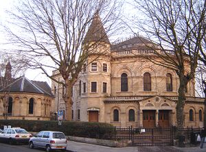
      Lower Clapton
      ١ مراجع
      Imported from Wikidata item الإنجليزية