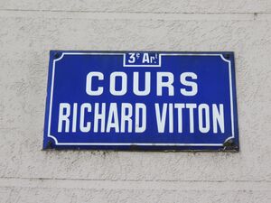
Cours Richard-Vitton الإنجليزية (Q3130054)
street in 3rd arrondissement of Lyon, France الإنجليزية
| اللغة | التسمية | الوصف | أسماء أخرى |
|---|---|---|---|
| العربية | لم تُضف التسمية |
لا يوجد وصف |
|
| الإنجليزية | Cours Richard-Vitton |
street in 3rd arrondissement of Lyon, France |
بيانات
Wikidata item الإنجليزية
coordinate location الإنجليزية
country الإنجليزية
instance of الإنجليزية
postal code الإنجليزية
Commons category الإنجليزية
OpenStreetMap relation ID الإنجليزية
image الإنجليزية
Lyon 3e - Cours Richard Vitton, extrémité ouest (avril 2019).jpg
٤٬٦٠٨ × ٣٬٤٥٦؛ ٤٫٩٦ ميجابايت
٤٬٦٠٨ × ٣٬٤٥٦؛ ٤٫٩٦ ميجابايت
١ مراجع
Imported from Wikidata item الإنجليزية
location الإنجليزية
place name sign الإنجليزية
Lyon 3e - Cours Richard Vitton - Plaque (avril 2019).jpg
٤٬٦٠٨ × ٣٬٤٥٦؛ ٣٫٣٨ ميجابايت
٤٬٦٠٨ × ٣٬٤٥٦؛ ٣٫٣٨ ميجابايت
language of work or name الإنجليزية
١ مراجع
Imported from Wikidata item الإنجليزية
different from الإنجليزية
Google Knowledge Graph ID الإنجليزية
part of الإنجليزية
shares border with الإنجليزية
Route de Genas الإنجليزية
coordinate location الإنجليزية
45°45'15.466"N, 4°53'2.026"E
١ مراجع
Imported from Wikidata item الإنجليزية
Rue Saint-Isidore الإنجليزية
coordinate location الإنجليزية
45°45'15.466"N, 4°53'2.026"E
١ مراجع
Imported from Wikidata item الإنجليزية
Rue du Vinatier الإنجليزية
coordinate location الإنجليزية
45°45'9.932"N, 4°53'53.970"E
١ مراجع
Imported from Wikidata item الإنجليزية
Cours du Docteur Long الإنجليزية
coordinate location الإنجليزية
45°45'11.102"N, 4°53'42.698"E
١ مراجع
Imported from Wikidata item الإنجليزية
Rue Bonnand الإنجليزية
coordinate location الإنجليزية
45°45'14.720"N, 4°53'8.470"E
١ مراجع
Imported from Wikidata item الإنجليزية
Rue Louis الإنجليزية
coordinate location الإنجليزية
45°45'14.011"N, 4°53'15.198"E
١ مراجع
Imported from Wikidata item الإنجليزية
Rue Camille الإنجليزية
coordinate location الإنجليزية
45°45'13.288"N, 4°53'22.135"E
١ مراجع
Imported from Wikidata item الإنجليزية
rue Saint-Charles الإنجليزية
coordinate location الإنجليزية
45°45'11.804"N, 4°53'36.341"E
١ مراجع
Imported from Wikidata item الإنجليزية
Rue Ferdinand Buisson الإنجليزية
coordinate location الإنجليزية
45°45'10.058"N, 4°53'52.804"E
١ مراجع
Imported from Wikidata item الإنجليزية

