Lordship Lane الإنجليزية (Q3278787)

من Marefa data
street in the London Borough of Haringey الإنجليزية
اللغة التسمية الوصف أسماء أخرى
العربية
لم تُضف التسمية
لا يوجد وصف
    الإنجليزية
    Lordship Lane
    street in the London Borough of Haringey
    • Berry Lane
    • Lordship Lane, Haringey

    بيانات

    Wikidata item الإنجليزية
    ٠ مرجع
    coordinate location الإنجليزية
    51°35'49.9"N, 0°6'34.9"W
    ١ مراجع
    Imported from Wikidata item الإنجليزية
    country الإنجليزية
    instance of الإنجليزية
    ١ مراجع
    Imported from Wikidata item الإنجليزية
    image الإنجليزية
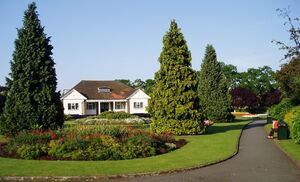
    Chapmans Park Lordship Lane N22.jpg
    ٢٬٠١٩ × ١٬٢٢٧؛ ٤٢٤ كيلوبايت
    ١ مراجع
    Imported from Wikidata item الإنجليزية
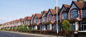
    Numbers 341 to 385 Lordship Lane N17.jpg
    ١٬٧٤٨ × ٧٥١؛ ٤٤٢ كيلوبايت
    ١ مراجع
    Imported from Wikidata item الإنجليزية
    Commons gallery الإنجليزية
    Lordship Lane
    ١ مراجع
    Imported from Wikidata item الإنجليزية
    connects with الإنجليزية
    Wood Green High Road الإنجليزية
    ١ مراجع
    Imported from Wikidata item الإنجليزية
    Tottenham High Road الإنجليزية
    ١ مراجع
    Imported from Wikidata item الإنجليزية
    Bruce Grove الإنجليزية
    ١ مراجع
    Imported from Wikidata item الإنجليزية
    Gladstone Avenue الإنجليزية
    ١ مراجع
    Imported from Wikidata item الإنجليزية
    historic county الإنجليزية
    ١ مراجع
    Imported from Wikidata item الإنجليزية
    part of الإنجليزية
    A109 road الإنجليزية
    ١ مراجع
    Imported from Wikidata item الإنجليزية
    Commons category الإنجليزية
    Lordship Lane, Haringey
    ١ مراجع
    Imported from Wikidata item الإنجليزية