rue Seignemartin الإنجليزية (Q3817261)
street in 8th arrondissement of Lyon, France الإنجليزية
| اللغة | التسمية | الوصف | أسماء أخرى |
|---|---|---|---|
| العربية | لم تُضف التسمية |
لا يوجد وصف |
|
| الإنجليزية | rue Seignemartin |
street in 8th arrondissement of Lyon, France |
بيانات
Wikidata item الإنجليزية
instance of الإنجليزية
country الإنجليزية
coordinate location الإنجليزية
described at URL الإنجليزية
named after الإنجليزية
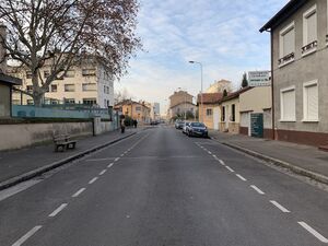
image الإنجليزية
Rue Seignemartin (Lyon) - 2019 (1).jpg
٤٬٠٣٢ × ٣٬٠٢٤؛ ٨٫٣٩ ميجابايت
٤٬٠٣٢ × ٣٬٠٢٤؛ ٨٫٣٩ ميجابايت
١ مراجع
Imported from Wikidata item الإنجليزية
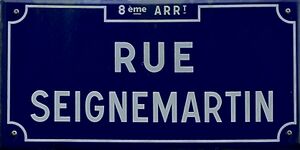
place name sign الإنجليزية
Plaque rue Seignemartin à Lyon 2019-04-26.jpg
١٬٦٧١ × ٨٣٦؛ ٢١٥ كيلوبايت
١٬٦٧١ × ٨٣٦؛ ٢١٥ كيلوبايت
language of work or name الإنجليزية
١ مراجع
Imported from Wikidata item الإنجليزية
OpenStreetMap relation ID الإنجليزية
postal code الإنجليزية
Commons category الإنجليزية
part of الإنجليزية
shares border with الإنجليزية
boulevard Ambroise-Paré الإنجليزية
coordinate location الإنجليزية
45°44'9.182"N, 4°52'59.178"E
١ مراجع
Imported from Wikidata item الإنجليزية
rue Pinton الإنجليزية
coordinate location الإنجليزية
45°44'18.852"N, 4°52'50.830"E
١ مراجع
Imported from Wikidata item الإنجليزية
Rue Pierre Sonnerat الإنجليزية
coordinate location الإنجليزية
45°44'18.852"N, 4°52'50.830"E
١ مراجع
Imported from Wikidata item الإنجليزية
rue Bataille الإنجليزية
coordinate location الإنجليزية
45°44'9.449"N, 4°52'58.886"E
١ مراجع
Imported from Wikidata item الإنجليزية
rue Longefer الإنجليزية
coordinate location الإنجليزية
45°44'21.253"N, 4°52'48.832"E
١ مراجع
Imported from Wikidata item الإنجليزية
Rue Nungesser et Coli الإنجليزية
coordinate location الإنجليزية
45°44'27.118"N, 4°52'43.846"E
١ مراجع
Imported from Wikidata item الإنجليزية
rue Kruger الإنجليزية
coordinate location الإنجليزية
45°44'13.870"N, 4°52'45.368"E
١ مراجع
Imported from Wikidata item الإنجليزية
Passage Tramuset الإنجليزية
coordinate location الإنجليزية
45°44'24.054"N, 4°52'46.452"E
١ مراجع
Imported from Wikidata item الإنجليزية
Rue des Maçons الإنجليزية
coordinate location الإنجليزية
45°44'22.744"N, 4°52'47.557"E
١ مراجع
Imported from Wikidata item الإنجليزية
rue Thomas Blanchet الإنجليزية
coordinate location الإنجليزية
45°44'12.318"N, 4°52'56.341"E
١ مراجع
Imported from Wikidata item الإنجليزية

