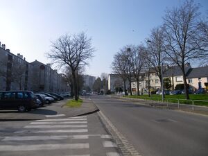
Boulevard Albert 1er الإنجليزية (Q4336692)
street in Rennes, France الإنجليزية
| اللغة | التسمية | الوصف | أسماء أخرى |
|---|---|---|---|
| العربية | لم تُضف التسمية |
لا يوجد وصف |
|
| الإنجليزية | Boulevard Albert 1er |
street in Rennes, France |
بيانات
Wikidata item الإنجليزية
instance of الإنجليزية
country الإنجليزية
coordinate location الإنجليزية
named after الإنجليزية
image الإنجليزية
Boulevard albert 1er a rennes - panoramio.jpg
٤٬٠٠٠ × ٣٬٠٠٠؛ ١٫٩٥ ميجابايت
٤٬٠٠٠ × ٣٬٠٠٠؛ ١٫٩٥ ميجابايت
١ مراجع
Imported from Wikidata item الإنجليزية
Commons category الإنجليزية
shares border with الإنجليزية
rue de Nantes الإنجليزية
coordinate location الإنجليزية
48°5'25.15"N, 1°41'33.83"W
١ مراجع
Imported from Wikidata item الإنجليزية
coordinate location الإنجليزية
48°5'24.58"N, 1°41'27.71"W
١ مراجع
Imported from Wikidata item الإنجليزية
coordinate location الإنجليزية
48°5'24.54"N, 1°41'26.16"W
١ مراجع
Imported from Wikidata item الإنجليزية
coordinate location الإنجليزية
48°5'24.72"N, 1°41'23.71"W
١ مراجع
Imported from Wikidata item الإنجليزية
coordinate location الإنجليزية
48°5'24.29"N, 1°41'21.48"W
١ مراجع
Imported from Wikidata item الإنجليزية
coordinate location الإنجليزية
48°5'24.29"N, 1°41'16.30"W
١ مراجع
Imported from Wikidata item الإنجليزية
coordinate location الإنجليزية
48°5'23.50"N, 1°41'8.38"W
١ مراجع
Imported from Wikidata item الإنجليزية
coordinate location الإنجليزية
48°5'23.06"N, 1°41'7.33"W
١ مراجع
Imported from Wikidata item الإنجليزية
Rue Le Guen de Kérangal الإنجليزية
coordinate location الإنجليزية
48°5'23.06"N, 1°41'4.70"W
١ مراجع
Imported from Wikidata item الإنجليزية
coordinate location الإنجليزية
48°5'22.34"N, 1°41'3.55"W
١ مراجع
Imported from Wikidata item الإنجليزية
coordinate location الإنجليزية
48°5'22.92"N, 1°40'56.06"W
١ مراجع
Imported from Wikidata item الإنجليزية
coordinate location الإنجليزية
48°5'21.08"N, 1°40'49.84"W
١ مراجع
Imported from Wikidata item الإنجليزية
coordinate location الإنجليزية
48°5'20.26"N, 1°40'38.35"W
١ مراجع
Imported from Wikidata item الإنجليزية
coordinate location الإنجليزية
48°5'20.11"N, 1°40'32.23"W
١ مراجع
Imported from Wikidata item الإنجليزية
avenue Henri Fréville الإنجليزية
coordinate location الإنجليزية
48°5'20.11"N, 1°40'28.70"W
١ مراجع
Imported from Wikidata item الإنجليزية
Rue de Châtillon الإنجليزية
coordinate location الإنجليزية
48°5'19.97"N, 1°40'19.88"W
١ مراجع
Imported from Wikidata item الإنجليزية
Rue des 25 Fusillés du 30 Décembre 1942 الإنجليزية
coordinate location الإنجليزية
48°5'25.15"N, 1°41'33.83"W
١ مراجع
Imported from Wikidata item الإنجليزية
