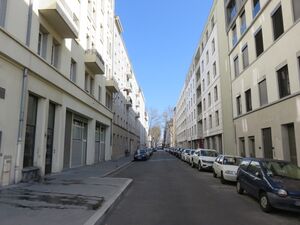
Rue Smith الإنجليزية (Q4524005)
street in 2nd arrondissement of Lyon, France الإنجليزية
| اللغة | التسمية | الوصف | أسماء أخرى |
|---|---|---|---|
| العربية | لم تُضف التسمية |
لا يوجد وصف |
|
| الإنجليزية | Rue Smith |
street in 2nd arrondissement of Lyon, France |
بيانات
Wikidata item الإنجليزية
instance of الإنجليزية
country الإنجليزية
postal code الإنجليزية
coordinate location الإنجليزية
Commons category الإنجليزية
image الإنجليزية
Lyon 2e - Rue Smith direction Perrache depuis la rue Casimir Perier (mars 2019).jpg
٤٬٦٠٨ × ٣٬٤٥٦؛ ٣٫٥٦ ميجابايت
٤٬٦٠٨ × ٣٬٤٥٦؛ ٣٫٥٦ ميجابايت
١ مراجع
Imported from Wikidata item الإنجليزية
OpenStreetMap relation ID الإنجليزية
place name sign الإنجليزية
Lyon 2e - Rue Smith - Plaque (mars 2019).jpg
٤٬٦٠٨ × ٣٬٤٥٦؛ ٤٫٥ ميجابايت
٤٬٦٠٨ × ٣٬٤٥٦؛ ٤٫٥ ميجابايت
language of work or name الإنجليزية
١ مراجع
Imported from Wikidata item الإنجليزية
part of الإنجليزية
shares border with الإنجليزية
Rue Paul Montrochet الإنجليزية
coordinate location الإنجليزية
45°44'21.232"N, 4°49'9.934"E
١ مراجع
Imported from Wikidata item الإنجليزية
coordinate location الإنجليزية
45°44'21.232"N, 4°49'9.934"E
١ مراجع
Imported from Wikidata item الإنجليزية
Rue Dugas Montbel الإنجليزية
coordinate location الإنجليزية
45°44'50.320"N, 4°49'34.651"E
١ مراجع
Imported from Wikidata item الإنجليزية
place des Archives الإنجليزية
coordinate location الإنجليزية
45°44'49.427"N, 4°49'33.838"E
١ مراجع
Imported from Wikidata item الإنجليزية
cours Suchet الإنجليزية
coordinate location الإنجليزية
45°44'46.514"N, 4°49'31.447"E
١ مراجع
Imported from Wikidata item الإنجليزية
Cours Bayard الإنجليزية
coordinate location الإنجليزية
45°44'35.614"N, 4°49'22.130"E
١ مراجع
Imported from Wikidata item الإنجليزية
Rue Marc-Antoine Petit الإنجليزية
coordinate location الإنجليزية
45°44'42.929"N, 4°49'28.362"E
١ مراجع
Imported from Wikidata item الإنجليزية
Rue Ravat الإنجليزية
coordinate location الإنجليزية
45°44'39.224"N, 4°49'25.183"E
١ مراجع
Imported from Wikidata item الإنجليزية
Rue Jacqueline et Rolan de Pury الإنجليزية
coordinate location الإنجليزية
45°44'25.649"N, 4°49'13.699"E
١ مراجع
Imported from Wikidata item الإنجليزية
Rue Casimir Perier الإنجليزية
coordinate location الإنجليزية
45°44'31.682"N, 4°49'18.779"E
١ مراجع
Imported from Wikidata item الإنجليزية
coordinate location الإنجليزية
45°44'29.987"N, 4°49'17.382"E
١ مراجع
Imported from Wikidata item الإنجليزية
Allée Lucien Bégule الإنجليزية
coordinate location الإنجليزية
45°44'29.987"N, 4°49'17.382"E
١ مراجع
Imported from Wikidata item الإنجليزية
Esplanade François Mitterrand الإنجليزية
coordinate location الإنجليزية
45°44'27.650"N, 4°49'15.391"E
١ مراجع
Imported from Wikidata item الإنجليزية
Rue Charles Baudelaire الإنجليزية
coordinate location الإنجليزية
45°44'27.395"N, 4°49'15.172"E
١ مراجع
Imported from Wikidata item الإنجليزية

