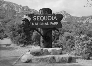
Ash Mountain Entrance Sign الإنجليزية (Q641564)
historical sign الإنجليزية
| اللغة | التسمية | الوصف | أسماء أخرى |
|---|---|---|---|
| العربية | لم تُضف التسمية |
لا يوجد وصف |
|
| الإنجليزية | Ash Mountain Entrance Sign |
historical sign |
بيانات
Wikidata item الإنجليزية
coordinate location الإنجليزية
country الإنجليزية
architectural style الإنجليزية
made from material الإنجليزية
inception الإنجليزية
depicts الإنجليزية
owned by الإنجليزية
instance of الإنجليزية
heritage designation الإنجليزية
start time الإنجليزية
٢٧ أبريل 1978http://data.marefa.org/entity/Q1985727
١ مراجع
Imported from Wikidata item الإنجليزية
Commons category الإنجليزية
located in protected area الإنجليزية
BabelNet ID الإنجليزية
continent الإنجليزية
fabrication method الإنجليزية
located on street الإنجليزية
Freebase ID الإنجليزية
location الإنجليزية
image الإنجليزية
Ash Mountain Entrance sign HAER.jpg
٥٬٣٠٩ × ٣٬٧٦١؛ ٢٫٧٤ ميجابايت
٥٬٣٠٩ × ٣٬٧٦١؛ ٢٫٧٤ ميجابايت
١ مراجع
Imported from Wikidata item الإنجليزية
وصلات الموقع
Marefa(٠ : لا وصلات)
ويكيبيديا(٢ وصلتان)
- enwiki Ash Mountain Entrance Sign
- frwiki Ash Mountain Entrance Sign
