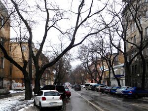
Troitska Street الإنجليزية (Q2791000)
street in Odesa, Ukraine الإنجليزية
| اللغة | التسمية | الوصف | أسماء أخرى |
|---|---|---|---|
| العربية | لم تُضف التسمية |
لا يوجد وصف |
|
| الإنجليزية | Troitska Street |
street in Odesa, Ukraine |
|
بيانات
Wikidata item الإنجليزية
Commons category الإنجليزية
instance of الإنجليزية
named after الإنجليزية
country الإنجليزية
topic's main category الإنجليزية
official name الإنجليزية
image الإنجليزية
Troitska Street, Odessa.jpg
٣٬٢٦٤ × ٢٬٤٤٨؛ ٦٧٦ كيلوبايت
٣٬٢٦٤ × ٢٬٤٤٨؛ ٦٧٦ كيلوبايت
١ مراجع
Imported from Wikidata item الإنجليزية
shares border with الإنجليزية
coordinate location الإنجليزية
46°28'33.668"N, 30°44'58.805"E
١ مراجع
Imported from Wikidata item الإنجليزية
Kanatna Street الإنجليزية
coordinate location الإنجليزية
46°28'34.151"N, 30°44'51.817"E
١ مراجع
Imported from Wikidata item الإنجليزية
Pushkinska Street الإنجليزية
coordinate location الإنجليزية
46°28'35.648"N, 30°44'31.132"E
١ مراجع
Imported from Wikidata item الإنجليزية
Rishelievska Street الإنجليزية
coordinate location الإنجليزية
46°28'36.174"N, 30°44'23.539"E
١ مراجع
Imported from Wikidata item الإنجليزية
Katerynynska Street الإنجليزية
coordinate location الإنجليزية
46°28'36.790"N, 30°44'16.105"E
١ مراجع
Imported from Wikidata item الإنجليزية
Ukrainskykh Heroiv Avenue الإنجليزية
coordinate location الإنجليزية
46°28'37.636"N, 30°44'5.237"E
١ مراجع
Imported from Wikidata item الإنجليزية
Preobrazhenska Street الإنجليزية
coordinate location الإنجليزية
46°28'38.338"N, 30°43'54.304"E
١ مراجع
Imported from Wikidata item الإنجليزية
Pokrovskyi Lane الإنجليزية
coordinate location الإنجليزية
46°28'37.517"N, 30°44'9.348"E
١ مراجع
Imported from Wikidata item الإنجليزية
Osipova Street الإنجليزية
coordinate location الإنجليزية
46°28'34.802"N, 30°44'41.406"E
١ مراجع
Imported from Wikidata item الإنجليزية
coordinate location الإنجليزية
46°28'33.668"N, 30°44'58.805"E
applies to part الإنجليزية
١ مراجع
Imported from Wikidata item الإنجليزية
46°28'38.338"N, 30°43'54.304"E
applies to part الإنجليزية
١ مراجع
Imported from Wikidata item الإنجليزية
Google Knowledge Graph ID الإنجليزية
OpenStreetMap relation ID الإنجليزية
location الإنجليزية
