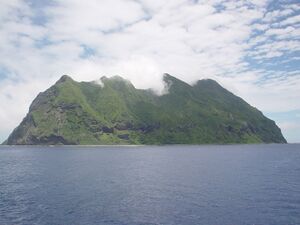
North Iwo Jima الإنجليزية (Q4344532)

من Marefa data
northernmost island of the Volcano Islands, now part of the Ogasawara Subdistrict of Tokyo, Japan الإنجليزية
اللغة التسمية الوصف أسماء أخرى
العربية
لم تُضف التسمية
لا يوجد وصف
    الإنجليزية
    North Iwo Jima
    northernmost island of the Volcano Islands, now part of the Ogasawara Subdistrict of Tokyo, Japan
    • Kita Iwo Jima
    • Kita Iwo Shima
    • Kita Iwo To
    • Kita Iwo-jima
    • Kita Iwo-shima
    • Kita Iwo-to
    • Kita Iwojima
    • Kita Iwoshima
    • Kita Iwoto
    • Santo Alessandro
    • San Alessandro
    • Isla Santo Alessandro
    • Isla San Alessandro
    • Santo Alessandro Island
    • San Alessandro Island
    • Saint Alexander Island
    • St Alexander Island
    • Hooge Meeuwen
    • Hooge Meeuwen Island
    • Hooge Meuwen
    • Hooge Meuwen Island
    • North Sulfur Island
    • N. Sulfur Island
    • N. Sulfur Is.
    • North Sulphur Island
    • N. Sulphur Island
    • N. Sulphur Is.
    • Kita Io Jima
    • Kita Io Shima
    • Kita Io To
    • Kita Io-jima
    • Kita Io-shima
    • Kita Io-to
    • Kita Iojima
    • Kita Ioshima
    • Kita Ioto
    • Kitaiwojima
    • Kitaiwoshima
    • Kitaioto
    • Kitaiojima
    • Kitaioshima
    • Kita-iwo-jima
    • Kita-iwo-shima
    • Kita-iwo-to
    • Kita-io-jima
    • Kita-io-shima
    • Kita-io-to
    • Kita-Iwojima
    • Kita-Iwoshima
    • Kita-Iwoto
    • Kita-Iojima
    • Kita-Ioto
    • Kita-Ioshima
    • North Iwo Shima
    • North Iwo To
    • N. Iwo Shima
    • N. Iwo To
    • N. Iwo Jima
    • North Io Jima
    • North Io Shima
    • North Io To
    • N. Io Jima
    • N. Io Shima
    • N. Io To
    • North Iwojima
    • North Iwoshima
    • North Iwoto
    • N. Iwojima
    • N. Iwoshima
    • N. Iwoto
    • N. Iojima
    • N. Ioshima
    • N. Ioto

    بيانات

    Wikidata item الإنجليزية
    ٠ مرجع
    Commons category الإنجليزية
    Kita Iwo Jima
    ١ مراجع
    Imported from Wikidata item الإنجليزية
    instance of الإنجليزية
    ١ مراجع
    Imported from Wikidata item الإنجليزية
    coordinate location الإنجليزية
    25°26'5"N, 141°16'51"E
    ١ مراجع
    Imported from Wikidata item الإنجليزية
    25°25'59"N, 141°16'54"E
    ١ مراجع
    Imported from Wikidata item الإنجليزية
    Freebase ID الإنجليزية
    ١ مراجع
    Imported from Wikidata item الإنجليزية
    country الإنجليزية
    ١ مراجع
    Imported from Wikidata item الإنجليزية
    part of الإنجليزية
    area الإنجليزية
    ٥٫٥٦±٠٫٠١٠٠٠٠٠٠٠٠٠٠٠٠٠٦٧٥ كيلومتر مربع
    point in time الإنجليزية
    ١ يناير 2021http://data.marefa.org/entity/Q1985727
    ١ مراجع
    Imported from Wikidata item الإنجليزية
    ٥٥٧ هكتار
    ١ مراجع
    Imported from Wikidata item الإنجليزية
    image الإنجليزية
    Kita-ioto.jpg
    ٦٤٠ × ٤٨٠؛ ١٤٤ كيلوبايت
    media legend الإنجليزية
    Kita-Iótó (التشيكية)
    ١ مراجع
    Imported from Wikidata item الإنجليزية
    elevation above sea level الإنجليزية
    ٧٩٢ متر
    ١ مراجع
    Imported from Wikidata item الإنجليزية
    width الإنجليزية
    ١٫٩ كيلومتر
    ١ مراجع
    Imported from Wikidata item الإنجليزية
    population الإنجليزية
    ٠
    ١ مراجع
    Imported from Wikidata item الإنجليزية
    length الإنجليزية
    ٢٫١ كيلومتر
    ١ مراجع
    Imported from Wikidata item الإنجليزية
    OpenStreetMap relation ID الإنجليزية
    6024796
    ١ مراجع
    Imported from Wikidata item الإنجليزية
    heritage designation الإنجليزية
    start time الإنجليزية
    2011http://data.marefa.org/entity/Q1985727
    part of الإنجليزية
    official name الإنجليزية
    Kita-iwoto and peripheral reefs (الإنجليزية)
    ١ مراجع
    Imported from Wikidata item الإنجليزية
    locator map image الإنجليزية
    Ogasawara Kita Iwojima.PNG
    ٧٥٦ × ٥٤٦؛ ٤٩٦ كيلوبايت
    ١ مراجع
    Imported from Wikidata item الإنجليزية
    aerial view الإنجليزية
    Kita-Ioto East 20120309.jpg
    ٢٬٠٤٨ × ١٬٥٣٦؛ ١٫٥٥ ميجابايت
    ١ مراجع
    Imported from Wikidata item الإنجليزية