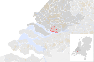
كرومستراين (Q608118)
بلدية في جنوب هولندا، هولندا
| اللغة | التسمية | الوصف | أسماء أخرى |
|---|---|---|---|
| العربية | كرومستراين |
بلدية في جنوب هولندا، هولندا |
|
| الإنجليزية | Cromstrijen |
former municipality in South Holland, the Netherlands |
بيانات
Wikidata item الإنجليزية
contains settlement الإنجليزية
postal code الإنجليزية
coordinate location الإنجليزية
country الإنجليزية
instance of الإنجليزية
start time الإنجليزية
١ يناير 1984http://data.marefa.org/entity/Q1985727
end time الإنجليزية
١ يناير 2019http://data.marefa.org/entity/Q1985727
replaced by الإنجليزية
Hoeksche Waard الإنجليزية
١ مراجع
Imported from Wikidata item الإنجليزية
shares border with الإنجليزية
Oostflakkee الإنجليزية
end time الإنجليزية
٣١ ديسمبر 2012http://data.marefa.org/entity/Q1985727
١ مراجع
Imported from Wikidata item الإنجليزية
١ مراجع
Imported from Wikidata item الإنجليزية
end time الإنجليزية
٣١ ديسمبر 1996http://data.marefa.org/entity/Q1985727
١ مراجع
Imported from Wikidata item الإنجليزية
start time الإنجليزية
١ يناير 2013http://data.marefa.org/entity/Q1985727
١ مراجع
Imported from Wikidata item الإنجليزية
start time الإنجليزية
١ يناير 1997http://data.marefa.org/entity/Q1985727
١ مراجع
Imported from Wikidata item الإنجليزية
Freebase ID الإنجليزية
inception الإنجليزية
located in or next to body of water الإنجليزية
topic's main category الإنجليزية
VIAF ID الإنجليزية
Commons category الإنجليزية
population الإنجليزية
١٢٬٧٧٢
publisher الإنجليزية
point in time الإنجليزية
١ يناير 2016http://data.marefa.org/entity/Q1985727
title الإنجليزية
Bevolkingsontwikkeling; regio per maand (الهولندية)
١ مراجع
Imported from Wikidata item الإنجليزية
١٢٬٧٩٧
point in time الإنجليزية
١ يناير 2017http://data.marefa.org/entity/Q1985727
publisher الإنجليزية
determination method الإنجليزية
resident registration الإنجليزية
١ مراجع
Imported from Wikidata item الإنجليزية
١٢٬٨٢٦
point in time الإنجليزية
١ يناير 2018http://data.marefa.org/entity/Q1985727
publisher الإنجليزية
determination method الإنجليزية
resident registration الإنجليزية
١ مراجع
Imported from Wikidata item الإنجليزية
١٢٬٠١٢
point in time الإنجليزية
1990http://data.marefa.org/entity/Q1985727
determination method الإنجليزية
publisher الإنجليزية
Data Archiving and Networked Services الإنجليزية
١ مراجع
Imported from Wikidata item الإنجليزية
١٢٬٧٩١
point in time الإنجليزية
2000http://data.marefa.org/entity/Q1985727
determination method الإنجليزية
publisher الإنجليزية
Data Archiving and Networked Services الإنجليزية
١ مراجع
Imported from Wikidata item الإنجليزية
١٢٬٧٨٩
point in time الإنجليزية
2010http://data.marefa.org/entity/Q1985727
determination method الإنجليزية
publisher الإنجليزية
Data Archiving and Networked Services الإنجليزية
١ مراجع
Imported from Wikidata item الإنجليزية
number of households الإنجليزية
٥٬٤٤٩
point in time الإنجليزية
١ يناير 2015http://data.marefa.org/entity/Q1985727
١ مراجع
Imported from Wikidata item الإنجليزية
٥٬٤٢٤
point in time الإنجليزية
١ يناير 2014http://data.marefa.org/entity/Q1985727
١ مراجع
Imported from Wikidata item الإنجليزية
٥٬٤١٢
point in time الإنجليزية
١ يناير 2013http://data.marefa.org/entity/Q1985727
١ مراجع
Imported from Wikidata item الإنجليزية
٥٬٤٢٠
point in time الإنجليزية
١ يناير 2012http://data.marefa.org/entity/Q1985727
١ مراجع
Imported from Wikidata item الإنجليزية
٥٬٣٨١
point in time الإنجليزية
١ يناير 2011http://data.marefa.org/entity/Q1985727
١ مراجع
Imported from Wikidata item الإنجليزية
٥٬٣٦٦
point in time الإنجليزية
١ يناير 2010http://data.marefa.org/entity/Q1985727
١ مراجع
Imported from Wikidata item الإنجليزية
official website الإنجليزية
١ مراجع
Imported from Wikidata item الإنجليزية
coat of arms الإنجليزية
GND ID الإنجليزية
located in time zone الإنجليزية
category of associated people الإنجليزية
elevation above sea level الإنجليزية
located in/on physical feature الإنجليزية
replaced by الإنجليزية
category for maps الإنجليزية
flag image الإنجليزية
coat of arms image الإنجليزية
Coat of arms of Cromstrijen.svg
٣٩٦ × ٥٦٧؛ ٢٤٢ كيلوبايت
٣٩٦ × ٥٦٧؛ ٢٤٢ كيلوبايت
١ مراجع
Imported from Wikidata item الإنجليزية
locator map image الإنجليزية
Map - NL - Municipality code 0611 (2009).svg
٣٠٠ × ١٦٠؛ ٥٣٠ كيلوبايت
٣٠٠ × ١٦٠؛ ٥٣٠ كيلوبايت
١ مراجع
Imported from Wikidata item الإنجليزية
NL - locator map municipality code GM0611 (2016).png
٢٬١٢٥ × ١٬٤١٧؛ ٤٨٢ كيلوبايت
٢٬١٢٥ × ١٬٤١٧؛ ٤٨٢ كيلوبايت
point in time الإنجليزية
١ يناير 2016http://data.marefa.org/entity/Q1985727
١ مراجع
Imported from Wikidata item الإنجليزية
image الإنجليزية
Klaaswaal - watertoren van dichtbij.jpg
١٬٠٠٠ × ١٬٥٠٠؛ ٧٨٠ كيلوبايت
١٬٠٠٠ × ١٬٥٠٠؛ ٧٨٠ كيلوبايت
١ مراجع
Imported from Wikidata item الإنجليزية
pronunciation audio الإنجليزية
306 Cromstrijen.ogg
١٫٣ث؛ ٢٤ كيلوبايت
١٫٣ث؛ ٢٤ كيلوبايت
language of work or name الإنجليزية
١ مراجع
Imported from Wikidata item الإنجليزية
وصلات الموقع
Marefa(٠ : لا وصلات)
ويكيبيديا(٧ وصلات)
- cawiki Cromstrijen
- dewiki Cromstrijen
- enwiki Cromstrijen
- eswiki Cromstrijen
- fawiki کرومسترین
- frwiki Cromstrijen
- trwiki Cromstrijen

